On October 18th, at 5:53 AM, I started north on the Benton MacKaye Trail fully unsupported. Yes, I aimed to move quickly, and yes, I wanted to replace just a bit of what I had given up when I chose to end my time on the Appalachian Trail. But more than anything I wanted a return to why I had started doing these mountain adventures to begin with. Wilderness, solitude, disconnect, quiet. Few long trails, particularly close to home, can offer those things as much as Benton MacKaye.
Only a few people even knew I was out there. But I did still want to be able to share this experience. The tracker below is on a time delay of exactly eight days, and I’ll be making daily recap posts of my experience on this trail less-traveled. I’ll share those posts on Instagram, and also update this page with the recaps each day.
If you find any value, inspiration, or entertainment from this, please support kids in western North Carolina through my ongoing fundraiser for Western Youth Network. If you can’t or have already contributed, please share this with friends! All donations are currently matched 100%. The trail is officially 287 miles – consider a donation per mile. With the match, 100 people averaging 50 cents per mile puts us nearly at the goal! Or 1K people averaging just 5 cents per mile, or just 1 person averaging $50 per mile… 😂
For my international friends, if you’d like to contribute but are unable to do so using the link, you can Venmo me @randomforestrunner, or message me and I can give bank transfer info. I’ll pass along the donation in your name.
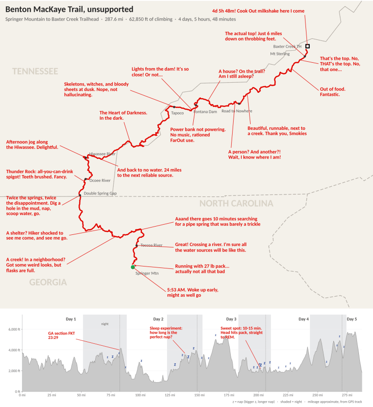
If you just want the summary, my tl;dr race report map is below.
“Live” Tracker
This is exactly 8 days behind. It’s just like watching it on tape delay. I mean TiVo. I mean DVR. No… on demand! That’s what we do these days. Anyway, it’s just as exciting if you use your imagination a bit. And if you think you already know the outcome because I’m posting this, well… have a good look around this blog at all that I’ve openly shared – there are plenty of both failures and successes.
| Distance (mi) | Ascent (ft) | |
|---|---|---|
| Completed | – | – |
| Remaining | – | – |
Calories**
- Burned (kcal)
- –
- Consumed (kcal)
- –
- Carbs (g)
- –
- Protein (g)
- –
- Fat (g)
- –
Time Lost*** (h:mm)
- Total
- –
- Sleep
- –
- Water
- –
- Navigation
- –
- Pack
- –
- Care
- –
Daily Recaps
These are mainly copy / paste from daily Instagram posts, for those who prefer to view it here and to have it all in one place at the end.
Day 0
Springer Mountain to Baxter!

Oh, that’s Baxter Creek Trailhead, not Baxter State Park. This is the Benton MacKaye Trail. Also, this happened last week. This was unsupported, so the tracker and my upcoming posts are intentionally delayed. Time is an illusion anyway.
The BMT goes nearly 300 miles through rugged wilderness from Georgia to the Smokies. Its southern terminus is right next to the Appalachian Trail’s, they intersect a few times, and yes their northern terminus locations even have similar names.

But the experiences are very different. The AT is “a footpath for those who seek fellowship with the wilderness,” but it has become so much more: an incredible community, trail towns, iconic landmarks and views, a well-trod connective thread tying Georgia to Maine. The BMT is a faint path meandering quietly through the woods. Those who do it in its entirety had better seek fellowship with the wilderness, because that’s about all they’re going to get.

It seemed perfect. Just me and the mountains. Unsupported, unknown. I’m grateful for the amazing support I’ve received over the years, but sometimes we need true solitude, and I needed to get back to why I started doing these things.
I mentioned the idea to my wife Jessi and coach David Roche a month earlier, and they gave it the green light. I found a week when I could squeeze it in between family activities and, hopefully, before shin-deep leaves made the trail un-runnable. Bob Stewart, who set the unsupported FKT this year, was the only other person I told. He was so genuinely kind, helpful, and thrilled to see someone getting out on this trail. Critically, he helped me find a ride back to the start (thank you Nathan Gressett!).
I considered keeping this quiet. You know, just go for a hike like most people do. But I knew this would also be one of the best ways I could continue my AT fundraiser for Western Youth Network, supporting kids in western North Carolina. I’m still matching every donation 100%. If you know someone who loves dot watching, please share!
Day 1 – Springer to Tennessee (Mile 82)
I started down Springer Mountain in the dark at 5:53 AM, my 27 pound pack actually riding pretty comfortably on my back. I had planned on setting off at first light, but I woke up early. It was a calm, chilly morning, my breath and rustling leaves the only sounds around.

I made great time to the Toccoa River, grabbing my first refill and lamenting the lost minutes as my now frozen fingers slipped the flasks back into my pack. Soon, losing only a few minutes to water sounded like a fantasy. The area has been in a drought, and the remnants of Hurricane Isaias a week earlier did not fill the creeks and springs like I hoped. Fortunately, I’m experienced at following vague directions to find things in the woods. Comments on the FarOut app led me to pipe springs and other sources a bit off trail that might have a trickle of water.

At times the trail was a faint path through the woods and at other times I was passing through random neighborhoods. I went from what felt like remote wilderness, not crossing paths with anyone on the trail all day, to going through a neighborhood and having someone shocked that I was getting (and drinking!) water out of a creek. I felt like Mowgli wandering into a village.
I passed by the final neighborhood, along with the Benton MacKaye Trail’s one and only shelter, at last light. I pulled out my headlamp, eager to reach the Tennessee border. It’s 83 miles in, at Double Spring Gap. Twice the springs, twice the disappointment – both were nothing more than mud, but I was desperate. I dug out a spot deep enough to scoop from, and took a strategic nap for a few minutes while the sediment settled back to the bottom of my pool. What would that person from the neighborhood think of me now?
I got enough water to last me till the next (hopefully) flowing creek. Overall, things were looking pretty good. The weather was great, the woods were beautiful, and I had just crossed into my home state in under 24 hours. Tennessee, Tennessee, ain’t no place I’d rather be.

Day 2 – Ocoee to Tellico (Mile 153)
One of my favorite things growing up in East Tennessee was the rivers. Small, swift, wild ones like the Obed that we used to float down fishing from inner tubes. Massive ones like the Clinch and Tennessee, dammed to form the lakes I loved spending my summers on.

I loved that my full day in Tennessee would be filled with them. I started off descending to Thunder Rock Campground, which was a great place to get myself sorted for the day. Brush my teeth, switch out my food bags, tape a few areas before they became real problems, and enjoy the luxury of an all-you-can-drink public spigot. I lost some time, but it felt well worth it.

I immediately crossed the Ocoee River, site of the 1996 Olympic whitewater events, before heading back up into the woods. Less than 20 miles later I was down again and enjoying an afternoon run along the Hiwassee. Even with the rivers, my water problems weren’t over. It was a tough 24 miles to the next water source after leaving the Hiwassee. I drank my fill, filled an extra flask, and knew I would still have to ration for a while. Cooler temperatures were arriving with the evening, which was a huge help.
But of course darkness was also arriving. I had already struggled a bit with sleep on night 1, and night 2 is when things really get interesting. My plan from the outset was to test some different sleep strategies. I didn’t have the pressure of racing, I had no crew or aid stations, and I could really sleep whenever and wherever for however long.
My great ambition is to turn my “sleep attacks” from my greatest weakness into a strength. Trying to fight them off, struggling to keep my eyes open, has always been the most miserable and difficult part of multi-days for me. I don’t mean type 2 fun. I just mean flat out miserable. But what if I could figure out just the right amount to push back against them, just the right length of nap to take to vanquish them, and then use them to get exactly the sleep I need almost on demand?
I had from the Hiwassee to the Tellico to gather some data.
Day 3 – Tellico to Fontana Lake (Mile 210)
I finished the hardest, longest descent of the trail only to find myself running through bloody sheets, skeletons, and ghost sounds. No, I wasn’t hallucinating. I had just arrived at Tapoco Lodge, where they had an outdoor haunted house at the trailhead.

The actual people were more startling than the ghouls – I had spent most of the last 2 days in sections so remote they’re given names like “The Heart of Darkness.” I hurried past. Daylight was fleeting and I had my sights set on the comfort of the most familiar spot on the route – Fontana Dam. I’ve slept in the parking lot there more times than I care to admit, and I wanted to get to it before my body decided to add to the tally.

On the map, it seemed simple. A steep but relatively short climb, a bit of a ridge run, then down to the dam. I was far too optimistic. The descent was a steep, winding route covered in shin-deep leaves. I was taunted by lights from the dam in the distance. It was right there! But so far away. I wound down and around Fontana Village on an overgrown circuitous route that many people had clearly bypassed in favor of the much more direct and easy road running alongside it.
I finally arrived just before midnight. Like at Thunder Rock the day before, I used it as a staging ground – a public spigot and a nice spot to sort my pack, brush my teeth, and prepare myself for the long overnight miles around the lake.
My power bank had stopped working. It was now just added dead weight, and I would have to ration my phone and tracker batteries. I would no longer have music among my tools for staying awake and I would have to severely restrict use of the FarOut app to look for water sources. Packing enough extra headlamp batteries to not need to recharge them was suddenly a run-saving decision.
Any thoughts of a sub 4 day finish were evaporating… but “only” the length of the Smokies separated me from the finish.
Day 4 – Fontana to Hyatt Ridge (Mile 270)
Just one more. One more nap and I’ll be good. Like a kid sneaking one more cookie, I quickly lay down and dozed off. I was back up in minutes, and found myself passing by a house. On a trail. In the middle of the Smokies. Maybe I hadn’t actually woken up?
I had tried to sleep for as long as an hour, but found that 10-15 minutes was my sweet spot. It was enough to end a sleep attack and at this point my body was diving straight to REM every time as soon as my head hit my pack. After just 10 minutes, I’d wake up from a dream in a puddle of drool. So dreaming the house seemed plausible, but it was the very real Calhoun House along the Lakeshore Trail. I was entering the heart of the Smokies.
A person? Yes, there’s one! And another! Tourists and leaf peepers everywhere! Within minutes the number of people I’d seen along the trail doubled. I confidently ran through the darkness of the Road to Nowhere tunnel and popped out at the parking area on the other side.
I knew exactly where I was. When I do these things, I study the important information (terrain, water, conditions, etc.) but I like to leave the details a bit of a mystery – to feel like I’m actually out exploring and discovering new things. Sometimes discovering old, familiar things is even better.
I had been concerned that the Smokies would be rough. Some trails there are hiker highways. Others are trails in name only. They’re wild, and rough. I headed up Noland Creek on a forest road – smooth, runnable, slight uphill alongside all the water I could drink and a full 360-degree tapestry of vibrant fall colors.

My legs were still surprisingly good. After the climb I felt like I was skipping down the other side, arriving at the bottom at last light. I got my headlamp and swapped out food and gear one last time. For once in my life I had been eating too well, and I realized I needed to start rationing a bit.
But I’ll be good. One more night. Just one more.
Day 5 – Mount Sterling
I was out of food entirely with about five hours left. Only Mount Sterling remained between me and the finish, but my stomach was already angry, growling loud enough for me to hear it above the crunch of the thick layer of fresh leaves. It was fine. I had run longer than that without food before, like on my 1st Pennine Way when I couldn’t get anything down because it turned out I had an ulcer. But it made the remaining miles seem miserable, and I wanted nothing more than for what had been an enjoyable run up to that point to just be over.
I had been trying to ration food, but a brain on its 5th day of severe sleep deprivation has the same impulse control as a 3 year old. “What do you mean you have another creme pie?! You might want it later?! What’s ‘later’ mean? Eat it! Eat it now!”
My feet started throbbing, as if in solidarity with my stomach. Just one mile at a time. Just keep going, and I’ll get there. The climb was one of those that seemed to never end – coming up to what appeared to be the final peak only for the trail to turn and skirt around its side to aim at yet another slightly higher peak behind it. Just keep going. Every other time in my life when it had seemed as if something would never end… it did, in fact, end.

The sooner I finished, the sooner I could dip my feet in the cold creek at the bottom and then head to the nearest Cook Out for a tray combo and milkshake. Turn the pain into motivation.
Finally, the top! I skipped the scenic view from the fire tower and kept my feet shuffling downhill. Six miles, all down. I zoned out and put my legs on autopilot. I’ve never had a true visual hallucination, but I do get auditory hallucinations. The whole way down I heard “Crazy Game of Poker” coming from the rocks, the trees, the creek… the creek – that’s the finish! I crossed the bridge to the northern terminus in time for Nathan to get these pictures with 2% battery left on my phone.

4 days, 5 hours, 48 minutes. A new unsupported and overall fastest known time (FKT) for the Benton MacKaye Trail, with an FKT for the Georgia section along the way (23 hours, 29 minutes).
Milkshake choice: pumpkin pie + Oreo
Recovery and Reflections
Five days earlier, before I started, Nathan Gressett had told me he could be at the trailhead Thursday at noon. I arrived at 11:41 AM. After I got myself cleaned up just a bit he took me straight to the nearest Cook Out, and then back down to Springer Mountain where my vehicle waited for me. Then I had to double back the other direction to get home ASAP. Jessi was heading out of town with two of the kids for the weekend, and I was at home with the other two, including for a soccer championship game for one of them.


Left for the start straight from the final cross country meet, made it back for the final soccer game. Boom, that’s how we do it.
This was, honestly, the first result I’ve felt good about in over two years, since the 2024 Old Dominion 100. Over half that time was spent dealing with a latent, unidentified injury, but even after learning that, it’s easy to question if that was really it or if I’d just lost a step. My legs actually felt pretty good throughout, with minimal soreness afterwards.
There are of course things I could have done better, and especially after digging through my data and seeing some of the time lost numbers shown in the tracker, part of me thinks, “dang, I could have definitely gone under 4 days!” But part of the fun of these massive adventures is that almost never does everything go right. The closest I’ve come was probably my 2nd Pennine Way, but even that had a hail storm on the last day and a 40 minute stop in Gargrave that I still really regret.
And no matter how these things go, there are always many valuable (also not valuable) reflections and lessons to be learned. Below are a few of the persistent thoughts I’ve had in the week after.
1. Unsupported multi-days are hard
Well, duh, of course they are. But I think most people mainly just think about the pack weight. I’m guilty of that myself. And yeah, it’s a big time penalty to start with a 27 pound pack. Even when it was down to about half that at the finish it was still a significant load to be hauling around if you’re “racing.”
For those unfamiliar:
- Unsupported = you have to carry everything except water from the start
- Self-supported = you can resupply yourself (mailing yourself packages ahead of time, buying things in town, etc.)
- Supported = crew can bring and carry everything for you
What’s bigger than the pack weight is all the little things you have to do yourself – finding and filling water, dealing with tough navigation, getting stuff in and out of your pack, etc. For the tracker, I had all the times that I stopped or doubled back identified in the GPX file, then manually labeled each of those. Over 8 hours of stuff that falls in the category of things a crew would have done for me if I had been supported. I think the “penalty” is closer to 15% rather than the 10% I had thought previously (this of course depends on things like navigation difficulty and water availability on each route).
Then there’s also the intangibles – having people there to motivate you, nag you to eat and drink, push you along when you just want to sleep.
And there’s the increased chances that a small thing ends the attempt entirely – gear malfunction, unexpected weather, lost item, minor injury that you can’t treat yourself. I lost my power bank and thus both music to keep me awake and a constantly available FarOut app for navigation and finding water. How much time that cost me, I don’t know exactly, but it definitely cost me. If I had instead lost my headlamp (and my backup, and my backup backup)? Game over.

2. But, maybe unsupported multi-days are for me
Originally, I gravitated much more towards unsupported and self-supported FKTs. Then I gradually drifted into the supported world, and thought that’s where I could do the best. I can assemble a great team almost anywhere, and it’s much more suited to my strengths (and weaknesses) as a runner. People can keep me awake, and I’m way too small to carry all that weight. Guys like Joe McConaughy, Jeff Garmire, and Will Peterson are giants next to me. The pack is a much larger addition for me in terms of percent body weight.
But maybe I was overthinking it. The pack weight didn’t really seem to bother me, and I was incredibly surprised by how comfortable it felt even in those early miles when it was at its heaviest. Sure, it slowed me down, there’s absolutely no way around that. I don’t care who you are. But it never felt like a massive burden or something causing abnormal or concentrated fatigue in any particular area.
I also enjoyed having to think and figure things out on my own. That in itself might help keep me awake more than having someone there prodding me along. It was like my own little Barkley. Me and my own wits and my own legs against the mountains.
A good few days of true solitude is also something I love having every once in a while.
3. Just definitely not multi-week
I’ve long said that the 60 – 120 hour range is my sweet spot for these things. That’s long enough that it feels like an adventure, but short enough that I’m not cancelling my life to do it. I think that 3 days is perfect. Despite that final day being perfect conditions passing through a beautiful section of the Smokies at peak fall foliage, I had a persistent thought of, “wow, this route would have been so perfect if it had ended at Fontana Dam. It was so fun up until then!”
A big part of that is losing my focus on the trail and wanting to get home. Critically, it’s a desire rather than a feeling of guilt. It’s almost exactly what I experienced on the Appalachian Trail this year – everything was going so well 10 days into it when suddenly it clicked in my head how much I needed to be back with my family. Pushing through for another day or two to finish – sure, that’s worth it to me in most cases. Doing another 30 just because people think I should or to get some record everyone will eventually forget about anyway – that’s not worth the price my kids would have paid from my absence.
4. Experiences > outcomes
I started doing these things mainly because I didn’t have time to hike the trails and see the places that I wanted. I figured I could do more of them if I moved faster. At some point, those speed goals started outweighing the trails and places I was seeing.
This one was just me, the mountains, and a trail I’d long wanted to do. It’s why I only told a few people ahead of time.
Both can co-exist, if chosen carefully. Fortunately, there are far more things where they do than what I can do in the time I have left. So there’s no reason to choose something where I can’t have both.
5. Normal is what we make it
In 2013, Jessi and I hiked the 211 mile John Muir Trail. There was an enormous amount of planning, preparation, research, and getting the right gear. It was a huge ordeal before we even set foot on the trail. In the years that followed, other big things were similar. Barkley, Spine, Pennine Way, Wainwrights, Long Trail – the preparation and the recovery were bigger and longer than the event itself.
This one, I really just up and did it. A month before, it wasn’t even yet an idea. A week before, I still hadn’t packed or prepped any gear or supplies, or studied the GPX or the route on FarOut. Two days before, I didn’t have a ride at the end. The day after, I was home and right back to normal life and every day activities. Jessi and the girls were away for the weekend, me and the boys had a great time at home.
None of this is to say anyone should do these things unprepared, or to say that I just winged it. My preparation was over a decade of accumulated knowledge and experience in doing these ridiculous, unreasonable things. The stuff that I once would have had to deliberately think about and double check are now ingrained in my head as instinct.* My recovery is also so much easier – I needed afternoon naps for a few days, had some swelling and some foot pain, but really was otherwise fine.
The point is that one person’s extreme is another person’s normal, and we can choose what our own normal is. There are countless things other people can do that absolutely blow my mind, and they do it without hardly thinking about it. Whatever it is that we want to do, whatever it is that we love – it might seem intimidating at first, but we can make it our normal. Get started and do it.
*If I’m going into an area or conditions that have even the slightest chance of being life-threatening you’d better believe I’m still deliberately going through those checklists. That’s another thing I learned the hard way early on.
6. Even unsupported, it’s not really solo
So much goes into preparing for and recovering from these things, and in picking up the slack in other areas while away. I obviously couldn’t have done this without Jessi’s support. They’re never truly solo.
The trail itself, and the knowledge of it, also don’t just come from nowhere. From the crews who maintain it to the people like Bob who have gone before and shared their experience, this is built on all of that.
I’ve shared this experience and some of these thoughts myself because I hope that others find value in them. I haven’t used my blog much in the last couple years, mostly because I haven’t had time for it. It’s been much easier to post quick recaps on Instagram and leave them there.
But I’ve been told so many times by people how they’ve read old blog posts to prepare for a race or how they’ve gotten other value from it. This is here, and it will stay here – for me, for my kids, for someone who wants to do the Benton MacKaye Trail, for anyone.
If you have found any value in this at all, even if just for entertainment, please consider a donation to the Western Youth Network at the link below. When I came off the AT I had to choose between mutually exclusive, conflicting responsibilities. Unfortunately I couldn’t fulfill them all. But this is one that I will continue, whatever it takes, until we’re able to meet that goal. Every donation has a 100% match. If you can’t give, or already have, please share with others!
Nutrition
Nutrition for this was pretty straight forward. I had a RecPak at the end of each day, and I divided everything else into mostly equal 8 hour bags, rotating one into each accessible side pocket on my pack. I didn’t want to be digging around my pack for one particular item.
- Nerds gummy clusters 18 oz
- Tailwind x32 (12 normal, 12 caffeinated, 8 recovery)
- Precision 30g chews x20
- Amacx fruit chews x20
- Golden Grahams cereal bar x16
- Little Debbie creme pie variants x12
- Snickers x8
- Amacx energy oat bar x12
- Little Debbie donut sticks x4
- Caffeine gum x24 (60 mg each)
- Electrolyte capsules (carried just in case, not used)
Totals
- Calories ~25K
- Carbs 4.9K g
- Protein 420 g
- Fat 400 g
The reason I ran out of food is because I had 12x 8 hour bags (96 hours), and thought, “I never eat everything. I’ll definitely have leftovers from those bags and then that can be what gets me to the end. I don’t want to be hauling a bunch of extra food across the Smokies.” Then I ate everything. Every time. There were zero leftovers, and I ran out almost right at 96 hours.
My only other real regret was not having more gummy clusters. I had those in daily bags instead of 8 hour bags, and I usually finished that day’s bag by noon. I also rely on the sour kick from those to combat cotton mouth.
Gear
Before I list my gear, I want to stress the caveat that this was done with a high confidence mild forecast – no extreme temperatures or heavy rain or wind. The lows I experienced were probably a bit above freezing, which on its own (without rain and wind) isn’t a real problem. Always carry what you would need if immobilized for any conditions that might happen. Be especially aware of remote stretches of the route where you have no easy way to bail and get to safety. There have been plenty of experienced people who have gone out for a “quick easy run” and ended up dying from exposure and/or putting search and rescue teams at risk because they got injured or lost and weren’t prepared to be stuck out there overnight.
Part of this requires knowing how to interpret and how far out to trust the forecast in a given area at a given time of year. Mountain weather can be very unpredictable – again see my Sonora Pass hike as an example. In UK mountains, I’d trust today’s forecast, feel pretty good about tomorrow’s, start to be skeptical of day 3, and by day 4 regardless of what the forecast said at the start I could be getting hit by 70 mph wind and sleet from a named windstorm (e.g. The Grand Round).
Here, for the forecast I had 4 days out, I was absolutely confident I wouldn’t be facing extreme conditions, and that cut down slightly on what I was carrying. Also, having said everything above, there’s a big difference between safety and comfort. I don’t need (and actually don’t want to be!) comfortable. For those who know the Spine kit list… just think, I did all this without a spork! 😉 I think I remembered everything in the lists below, but I might have forgotten a small item or two.
All apparel is La Sportiva other than the XOSKIN socks and base layers. For shoes, I started a half size up with two pairs of socks underneath, planning to strip a pair of socks as my feet swelled. I did that on day 3, and then on morning 4 I washed my feet off in a creek and put on a fresh pair of normal socks. I believe that those two times, my one bivy nap, and a few quick removals to knock dirt and debris out, are the only times my shoes came off. My one regret (other than my power bank dying) was not taking the tights. It’s such a pain to get them on and off, but my legs did get a bit chilly at night.
Shoes + Apparel (worn)
- Prodigio Pro
- Flow shorts and shirt
- Stream Cap
- Session Tech Gloves (medium weight convertible gloves / mittens – I get cold hands easily)
- Ethereal Pro jacket (lightweight rain jacket)
- Wall Breeze Stretch jacket (lightweight wind jacket)
- XOSKIN toe socks and normal socks x2
- Generic buff (from the Ivana gelateria along the Tor Des Geants course)
Apparel (packed, never used)
- Wool40 top and pants (wool base layer)
- Wooly Beanie
- Auster shorts
- XOSKIN boxer brief liner
- XOSKIN long sleeve (light base layer)
- XOSKIN toe socks and normal socks
Apparel (ditched just before starting after checking final forecast)
- Lumina 100 down jacket
- Aequilibrium Lite GoreTex jacket
- Drizzle Overpants
- Triumph tights
- Race over-mittens
Accessories
- La Sportiva Aeris 26 liter pack
- Petzl Nao+ headlamp with 5 batteries (I used 4, each one just made it through a night)
- Petzl Actik Core headlamp with 2 batteries (backup, unused)
- Petzl Bindi (backup backup, unused)
- Sidas Trail insole (zero rolled ankles!)
- Leki Ultratrail FX.One Superlite (these are really light weight, and I took extra caution early to be sure I didn’t break them)
- COROS Vertix 2 (had about 20% battery left at the end)
- Garmin inReach Messenger (was supposed to last 14 days, wouldn’t have made it 2 without recharging before my power bank died… I think a combination of the forest cover plus how I had it positioned. It did fully die on the final night.)
- Phone (used for FarOut app, music on night 1, and pics + videos)
- 7000 mAh power bank (failed me on night 2 and was dead weight afterwards)
- Charging cables (which also became dead weight)
- Shokz OpenRun Pro 2 (used on night 1, then dead weight since I had to conserve my phone’s battery)
Other
- Sidas anti-friction cream
- 4x 500 ml soft flask with 3x HydraPak filter cap
- KT Tape (3 stirrups on each ankle plus extra pre-cut strips)
- Bear Butt Wipes
- Travel toothbrush and toothpaste
- Basic first aid kit
- Compass
- Emergency blanket
- Exped Uno ultralight bivy


Hope it all went well (surprisingly difficult not to trawl the internet for spoilers)
I don’t think you’ll find any spoilers. 😂 Only a handful of people know the outcome.
I think a few more know now. . Well done (has been fun keeping a track on this from Somerset). I’m inspired to get out on Exmoor again soon
Thank you. I was just submitting this on the FKT website and having a look at my Somerset 3 Peaks FKT… still one of my proudest! Enjoy Exmoor, it’s beautiful
I reall like the way you write! Thanks for sharing!
Thanks so much Kerstin! Just finished up the post (after my delayed finish on the tracker)
Congrats on your FKT as well as learning more about yourself and what makes you happy. Maybe the mental and intellectual requirements of an unsupported event are the extra elements that makes it the best challenge for you. And thank you for sharing your experiences with us. Not everyone puts their thoughts down for others to read and I appreciate the time you take to do so.
Keep going!!
Thank you Jackie, that just might be the case!